About this region:The Gulf Island north of Saltspring create a sheltered inner sea that is invariably several steps more placid than most other locations on the British Columbia coast, even adjacent locations such as the Strait of Georgia. This is thanks in large part to the land bridge of Galiano, Valdes and Gabriola Islands. Together they shelter a rich collection of island clusters where land and water combine for a rare visual and ecological richness. These can be found in places such as Wallace Island and de Courcy islands, where sandstone sculptures, an arbutus ecology and intertidal life create a subtle but rich tapestry of destinations.
Outside that protected basin, the attractions change. Here you get wilder sea conditions and geography, along with wilder waterways to reach them – such as Porlier and Gabriola passes. Once outside, though, treats include Dionisio, a provincial park set on the outskirts of Porlier Pass, and Wakes Cove, a forested retreat on the north tip of Valdes Island. Valdes constitutes the largest of the Gulf Islands without ferry or electrical service, making it a relative enclave from traffic and congestion. It and other locations present a fantastic menu of locations to explore.
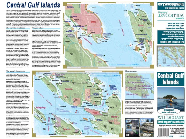
About this mapsheet:This mapsheet covers the waterways in the central section of the Gulf Islands,notably Galiano Island in an unbroken unit. Key attractions are the many provincial parks including Wallace Island and Dionisio, among others.
The mapsheet layout:The layout is a regional overview on the full page of one side, and on the other side a detailed closer-perspective view of Nanaimo Harbour as well as a regular scale showing Gabriola Island. Also included are planning details such as expected water conditions, trip planning information and campsite information.
The mapsheet construction:The mapsheet is created by Wild Coast Publishing using some of the latest technology available to provide a high-quality printed image on waterproof/durable synthetic polymer stock. The stock is picked as the best for the purpose, and is significantly thicker than most papers at 10 mil weight.