About this region: The Gulf Islands off east Vancouver Island offer one of the most benign coastal climates in Canada. It is often referred to as Mediterranean in nature, and results in an ecology that in many ways has more in common with northern California than the rest of British Columbia. The natural native forest here is composed primarily of the majestic Douglas-fir, but nearshore is where the environment shines. Here you will find Garry oak, rocky mountain juniper and arbutus plus a plethora of unusual coastal plants that thrive on the thin soil cover and ocean spray.
Add to this a regular parade of marine life including dolphins, killer whales, seals, sea lions and a wide range of seabirds and raptors, and it is likely a visit here will leave you with a keen appreciation for the varied and precious ecology. Much of the best is now captured in perpetuity through the Gulf Islands National Park Reserve. Some of the most magnificent of those park’s many and varied parcels are on Saturna Island, where most of the south shoreline is protected within the national park, including the magnificent cliffs of Brown Ridge and Monarch Head. Campsites dot the region and so make a wonderful circuit. Add the many services such as pubs to round out a delightful trip!
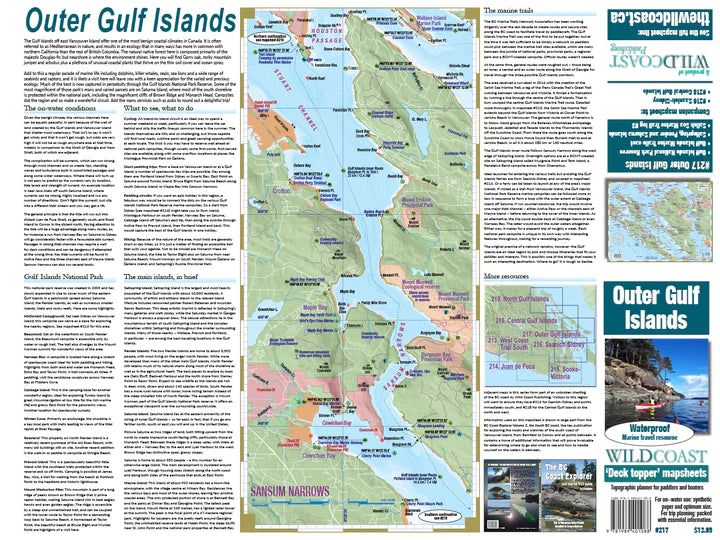
About this mapsheet:This mapsheet covers the waterways in the easternmost extent of the Gulf Islands, and so includes all of Saltspring Island, Saturna, Penders, Mayne and South Galiano, as well as all the smaller islands as far south as Swartz Bay. This makes this mapsheet the ideal travel companion for trips anywhere in these outer islands to destinations such as Cabbage Island, Narvaez Bay, Prevost Island, Sansum Narrows and Portland Island as far as Montague Harbour. Those heading north from Montague will want mapsheet #218, the Central Gulf Islands. Montague Harbour makes the ideal location to switch between mapsheets on a transit.
The mapsheet layout:The layout is a regional overview on the full page of one side, and on the other side a detailed closer-perspective view of the complex waterways around Swartz Bay and Coal Island to Portland Island. Also included are planning details such as expected water conditions, what to see and do, the First Nations context, launching locations and background on the Gulf Islands National Park Reserve.
The mapsheet construction:The mapsheet is created by Wild Coast Publishing using some of the latest technology available to provide a high-quality printed image on waterproof/durable synthetic polymer stock. The stock is picked as the best for the purpose, and is significantly thicker than most papers at 10 mil weight.